The Modern and Authentic System of Universal Geography containing and accurate and Entertaining Description of Europe, Asia, Africa and America etc ( 1807) by George Alexander Cooke
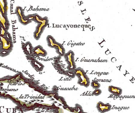
The Bahamas are situated to the south of Carolina between twelve and twenty-eight degrees north latitude and seventy-three and eighty-one degrees west longitude. They extend along the coast of Florida quite down to the Isle of Cuba; and are said to be five hundred in number, some of them only mere rocks; but twelve of them are large, fertile and in nothing different from the soil of Carolina. They are however, almost uninhabited except Providence, which is two hundred miles east of the Floridas; though some others are larger and more fertile, on which the English have plantations. Between them and the continent of Florida is the Gulph of Bahama, or Florida, through which the Spanish galleons sail in their passage to Europe. These islands were the first fruits of Columbus's discoveries; but they were not known to the English till 1667 when Captain Seyle, being driven among them in his passage to Carolina, gave his name to one of them, and being a second time driven upon it, gave it the name of Providence. The English, observing the advantageous situation of these islands for a check on the French and Spaniards, attempted to settle them in the reign of Charles II. Some unlucky incidents prevented this settlement from being of any advantage, and the isle of Providence became a harbour for the buccaneers or pirates who for a long time infested the American navigation. This obliged the government in 1718 to send out Captain Woodes Rogers with a fleet to dislodge the pirates and for making a settlement. This the captain effected; a fort was erected, and an independent company was stationed in the island. Ever since this last settlement these islands have been improving, though they advance but slowly. In time of war, people gain considerably by the pirates condemned there; and at all times by the wrecks, which are frequent in this labyrinth of rocks and shoals. The Spaniards captured these islands during a former war but they were retaken by a detachment from St Augustine, April 7th, 1783. The chief town is Nassau.
Use the "Show me" link to locate the Bahama on the map. You may need to scroll down to see the Bahamas highlighted.

 Chapter 8